|
|
||
|
||
| Author: anony Date: 3/10/2023 9:29:47 AM +0/-0 Show Orig. Msg (this window) Or In New Window | ||
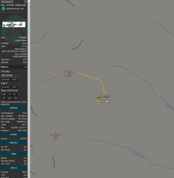
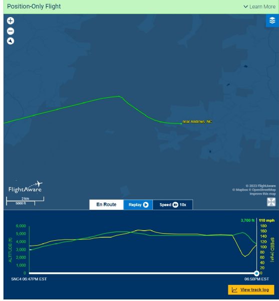
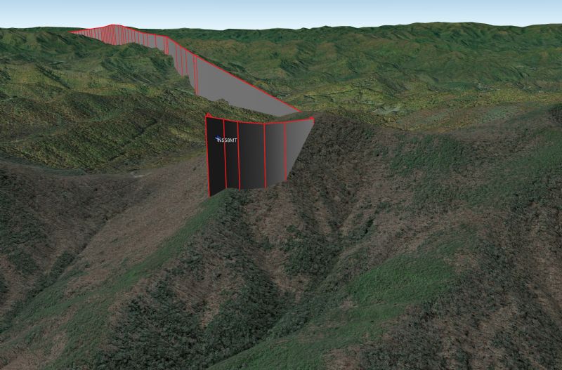
ADSB data shows after crossing the highest point in the flight path a pitch up and climb along with slowing down and a tight right hand 360. Data drops off but flight radar has more, pitches down and gains airspeed while losing altitude flowing the ridge line down for another 3 miles before landing in the first available area. Google earth overlay shows very little to no clearance on this ridge, there is also no sign of the landing gear in any of the photos at the scene. I hope I'm wrong but potentially clipped a ridgeline.
|
||
| Reply Return-To-Index Display Full Msg Thread Rules of Engagement Terms of Use | ||
|
|
||
|
||

 Life Force Track Log
+0/-1 Attached 3/10/2023 12:44:14 AM Life Force Track Log
+0/-1 Attached 3/10/2023 12:44:14 AM
 Life Force Track Log
+0/-2 reply 3/10/2023 9:22:15 AM
Life Force Track Log Life Force Track Log
+0/-2 reply 3/10/2023 9:22:15 AM
Life Force Track Log  +0/-0 anony 3/10/2023 9:29:47 AM
Life Force Track Log
+0/-0 Doubt it... 3/10/2023 5:45:45 PM
Life Force Track Log
+0/-1 Anywho 3/10/2023 7:52:24 PM
Life Force Track Log
+1/-0 anony 3/10/2023 8:59:49 PM
Life Force Track Log
+0/-0 Nose jack 3/10/2023 10:46:52 PM
Life Force Track Log
+1/-0 anony 3/10/2023 11:35:10 PM
Life Force Track Log
+0/-0 Nose jack 3/11/2023 12:11:42 AM
At 1:30 in vid the sheriff tells you what the pilot must have said (NT)
+1/-0 CFIT damaged T/R 3/11/2023 8:08:02 AM
How in g's name did he get it on that roadway? Holy smokes (NT)
+0/-0 I'm rather impressed. 3/10/2023 9:04:26 PM
Life Force Track Log
+3/-0 Best Guess 3/10/2023 11:30:37 PM
Life Force Track Log
+0/-0 Nose jack 3/11/2023 12:26:01 AM
Life Force Track Log
+0/-1 mee 3/11/2023 9:32:48 AM
Life Force Track Log
+1/-0 Captain Obvious 3/11/2023 1:59:10 PM
Life Force Track Log
+1/-1 Hmmm... 3/10/2023 9:48:23 AM
Life Force Track Log
+0/-0 Jojo 3/10/2023 8:13:20 PM
Nearby ASOS Reports
+1/-0 Anonymous 3/10/2023 9:15:37 PM
Life Force Track Log
+1/-3 Hmmm... 3/10/2023 9:44:28 AM
Life Force Track Log
+1/-1 GMR 3/10/2023 10:05:37 AM
Life Force Track Log
+0/-1 not really 3/10/2023 10:11:28 AM
Life Force Track Log
+1/-0 Wrong 3/10/2023 8:07:54 PM
You wouldn't know that by reading the article!
+0/-3 Erlanger this, Earl anger that..... 3/10/2023 9:06:18 PM
+0/-0 anony 3/10/2023 9:29:47 AM
Life Force Track Log
+0/-0 Doubt it... 3/10/2023 5:45:45 PM
Life Force Track Log
+0/-1 Anywho 3/10/2023 7:52:24 PM
Life Force Track Log
+1/-0 anony 3/10/2023 8:59:49 PM
Life Force Track Log
+0/-0 Nose jack 3/10/2023 10:46:52 PM
Life Force Track Log
+1/-0 anony 3/10/2023 11:35:10 PM
Life Force Track Log
+0/-0 Nose jack 3/11/2023 12:11:42 AM
At 1:30 in vid the sheriff tells you what the pilot must have said (NT)
+1/-0 CFIT damaged T/R 3/11/2023 8:08:02 AM
How in g's name did he get it on that roadway? Holy smokes (NT)
+0/-0 I'm rather impressed. 3/10/2023 9:04:26 PM
Life Force Track Log
+3/-0 Best Guess 3/10/2023 11:30:37 PM
Life Force Track Log
+0/-0 Nose jack 3/11/2023 12:26:01 AM
Life Force Track Log
+0/-1 mee 3/11/2023 9:32:48 AM
Life Force Track Log
+1/-0 Captain Obvious 3/11/2023 1:59:10 PM
Life Force Track Log
+1/-1 Hmmm... 3/10/2023 9:48:23 AM
Life Force Track Log
+0/-0 Jojo 3/10/2023 8:13:20 PM
Nearby ASOS Reports
+1/-0 Anonymous 3/10/2023 9:15:37 PM
Life Force Track Log
+1/-3 Hmmm... 3/10/2023 9:44:28 AM
Life Force Track Log
+1/-1 GMR 3/10/2023 10:05:37 AM
Life Force Track Log
+0/-1 not really 3/10/2023 10:11:28 AM
Life Force Track Log
+1/-0 Wrong 3/10/2023 8:07:54 PM
You wouldn't know that by reading the article!
+0/-3 Erlanger this, Earl anger that..... 3/10/2023 9:06:18 PM
|